Differences between German Autobahns and Interstate Highways

Many Americans want to know what is like driving on the German Autobahn is like. In reality, even though there is no national speed limit on the Autobahn, there are certain sections where there are nighttime speed limits or reduced speed limits due to condition, construction, and congestion. On rural autobahns, there is no posted speed limit and one is more than welcome to pick their favorite speed and go. Most major autobahns (i.e. the A5) have speed limit laws similar to the state of Montana, where there is no speed limit for cars from 06.00 to 19.00, but outside those times the speed limit can be between 120 and 130 km/h. (70-80 mph). Trucks and busses have a 100/110 km/h limit depending on the autobahn and the decal stickers required on such vehicles.

Like the interstate system, there is a minimum speed limit of 60 km/h (around 40 mph) on the autobahn. Any car that goes no faster than that speed limit is not allowed on the autobahn. Bicyclists, pedestrians, and mopeds are also banned from the autobahn. Anyone riding in a motorcycle must have a helmet on. The helmet must remain on as long the motorcyclist is seen outside in public, whether or not the motorcycle is in use.

Most of the information has come from the webmaster. Additional information is from Brian Purcell.

Here are the differences of the Autobahn and the Interstate system:

German Autobahn US Interstate System
Highway shield used

The shield is a hexagon very similar to that with white numbers on a blue field. It is always posted on a rectangular white field.

The shield is a cutout with white numbers on a blue field. Sometimes the state name may be above the number but that is not mandatory. The word "INTERSTATE" is white capital letters on a red field.

Speed limit Depends on the Autobahn even though there is no national speed limit on the Autobahn. Speed limits on the Autobahn is factored by the "3 C's": Condition (on both road and weather), Construction, and Congestion. The states decide. Montana has a very similar speed limit law to the one used on certain Autobahns during the day.
Right passing Illegal on the autobahn No rule.
Freeway guide sign colors

Blue: All guide signs on the Autobahn or at Autobahn interchanges on secondary roads are blue. On yellow guide signs, a blue plaque is used to indicate directions to the Autobahn. On blue guide signs, a yellow plaque is used in two instances: -on the Autobahn itself, a yellow rectangle with numbers is a Federal Highway shield.

-on secondary roads, on the Autobahn approach signs, a yellow plaque is used at the top of the sign to indicate the next destination along the secondary road.

White: Black on white is used to give directions to local activity centers (i.e. train stations, airports, downtown, etc.). A white plaque may be used for this on yellow or blue guide signs.

Green for the most part. Blue is used for service areas, orange is used for construction, and white is regulatory.

Exit numbering Sequentially (much like Georgia and Florida). Numbers are posted only on the initial guide sign for a junction and on the initial sign for a deceleration lane. States decide either milepost or interchange based numbering. California does not use any exit numbering at all, and Illinois does not post exit numbers on their toll ways at all.
Distance signs

Left photo is a distance sign with distances of nearby autobahn's control cities. Right photo is just a standard distance sign.

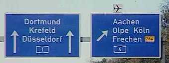
All routes on section of highway are posted on the upper part of the distance signs. Distances to cities are listed in reverse order, with the city furthest away listed first. Sometimes, distance signs give out distances on cities on nearby autobahns.

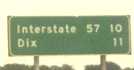
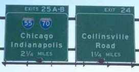
Usually the nearest exit and control city. States don't post highway shields on the upper part of the distance signs, however, they may use shields of the nearby highways on the distance signs (i.e. Florida). An major town may also be mentioned on the distance sign, but some states don't do this. In some states, the route number is spelled out (much like the example above).

Stand-alone signs Not used. Route numbers are always posted on distance signs. The direction of the highway is not posted by direction, but by the nearest city on that highway.

stand alone sign in Illinois

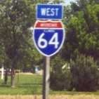
Used widespread. Some states have their state names on interstate shields, but a majority do not. The direction of the highway is also posted.

Posting all simultaneous routes

All routes are posted, regardless of highway type.

Depends on the state. While some states have no rule about simultaneous routes, others require all of them be posted. A few states (Colorado) only post the most-important route and hide the rest.

Aggressive driving ban Enforced strictly. Severe fines may result if caught. Enforcement is up to the state. Fines depends upon state law.
Numbering rules

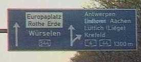
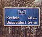
Photo shows A-544 branching off from its parent, A-44.

There is no rules for 2-digit numbers. Most 3-digit numbers follow the 3-digit interstate pattern. However, duplicates are not allowed.

Even numbers (0, 2, 4, 6, 8) usually go in a east-west direction. Odd numbers (1, 3, 5, 7, 9) generally go in a north-south direction. All but 1 3-digit interstate follow the rule by where x is a number 1-9 and the Y is a 2-digit number. If Y is a one-digit number (i.e. 2), the 3-digit number would be x02. The exception to the 3-digit interstate rule is I-238 in California -- it got its number mainly to the fact California ran out of legal x80 numbers. Duplicates are allowed as long as a state does not have 2 3-digit interstates with the same number.
Control Cities

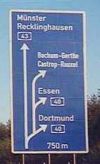
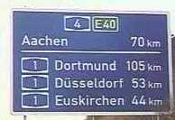
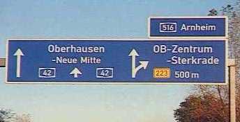
Top city on distance sign above route number (in this case, Munster) is the nearest major city on the autobahn you're currently on (here, A-43). On major freeway junctions, the control cities of other highways are also listed to the right of the sign.

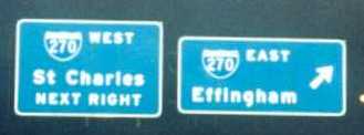
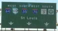
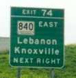
Depends on state. Some states use the nearest major city on a particular highway (see photo on the simultaneous routes), others uses local destinations (above, in this case of I-270 in Illinois, which considers it a rural interstate despite it being only 20 minutes from St. Louis). In some states, both methods may be used. Note that there are a few highways that don't have control cities at all.

Signing freeway junctions

inital guide sign for interchange 11inital guide sign for a major interchange

A diagram of what kind of freeway junction is always given in the initial guide sign, along with junction name and interchange number. However, in the next guide sign, the interchange number isn't posted and any route numbers involved are posted with their control cities.

final guide sign for interchange 11

second guide sign for Exit 74 on I-24 in TN

Diagrams of freeway junctions is never given unless the interchange is a confusing interchange. The interchange number and involved route numbers are almost always posted. The interchange number can be distinguished here due to the fact it is placed on a tab, usually on a wide or narrow format. The tab is placed on the top of the guide sign, and is usually right aligned unless the exit is on the left-hand side of the highway, where in that case, the alignment is on the left side. The distance is always given on initial guide sign but sometimes, the distance to the junction isn't given on the second guide sign like this one shown here.

Links: Listing of all 2-digit interstates by Zzyzx. Includes a brief overall description of each. Listing of all 3-digit interstates by Kurumi. This includes all dead and alive 3-digit interstates, and the new ones. The site has an better explanation of the numbering rules than given on this page. C.C. Slater's Freeway Junction Pages. Include junction lists of several interstates plus a huge page of links to other freeway junction listings. Autobahn Site. This is the one-stop webpage if one wants to download pictures from the autobahn. Most of my autobahn images (except for a couple) are from files I downloaded from this site. This site and the software packages are in German, but if you got an photo editor, all you really need is those zip files. Some zip files are over 2 MB in length, so plan on doing overnight downloads on some packages. The Autobahn by Brian Purcell. This site gives you everything that you will need to know about driving on the Autobahn. Autobahn Construction Site. This site is in German. Tank & Rast AG This includes an online map and brochure of the service areas along the autobahn. There is an German version of the site as well. The Autobahn from the book The German Way by Hyde Flippo. Includes a short summary of a chapter about the Autobahn in Germany. Autobahn 101, the rules of driving on German freeways. This site tells you all that you really need to know about driving on the Autobahn. Andy's Highway Kickoff Page by Andrew Field. Has links to almost all english-lanaguage sites on the web.

[ Email | Primer page | Home ] e-mail